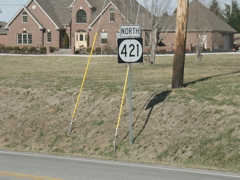
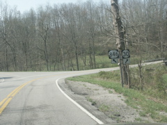
This sign wasn't part of my trip, but I took the pic a few weeks before and it's from the same general area, and was too good not to post. It's a sign goof. This should be a US 421 sign. It's located at Gray Hawk in Jackson County, at the junction with KY 1071.
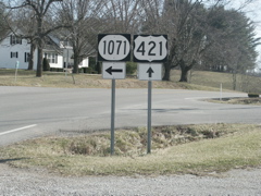
This is how the sign should appear. This is looking south on US 421.
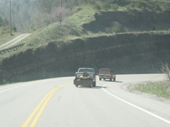
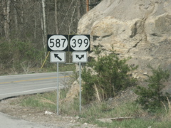
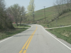
Now, the trip ... this is looking south on KY 587 in Lee County on Idamay Hill. This road was reconstructed in the early 1990s to eliminate dangerous curves and dropoffs. The old road went behind this rock cut and made a 90-degree turn down a hill, and was the scene of frequent slides and embankment failures.
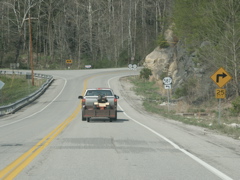
At the bottom of Idamay Hill on KY 587 in Lee County, looking at the intersection of KY 399 and 587.
Signage at the intersection of KY 587 and KY 399.
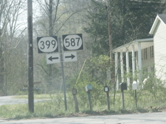
KY 399 and KY 587 split after a very short multiplex.
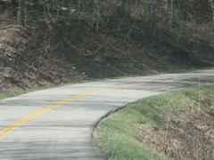
Typical view along KY 399 in Lee County, along Duck Fork.
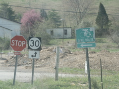
The end of KY 399 at KY 30 at Vincent in Owsley County, with an old 76 Bike Route sign also present.
Typical view along KY 30 in Owsley County, between Vincent and Travelers Rest.
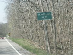
Travelers Rest (or Travellers, if you prefer) is a very small community in Owsley County, and no one seems to know how it got its name.
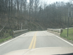
Very narrow bridge on KY 30 near Travelers Rest.
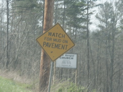
Watch For Mud On Pavement -- on KY 30 in Owsley County.
Intersection of KY 30 and KY 846 in Owsley County.
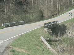
This old, narrow bridge is scheduled for replacement. It's just past the KY 846 intersection.
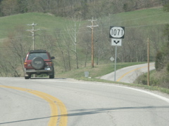
KY 1071 joins KY 30 just north of the Jackson County line.
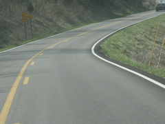
Typical view of KY 30 in Jackson County -- a very narrow, crooked, hilly route that carries a high volume of truck traffic.
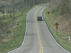
Another typical view of KY 30 in Jackson County.
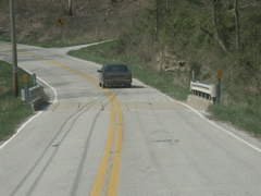
Another narrow bridge on KY 30, this one in Jackson County.
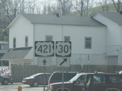
What a find! A US 30 sign goof, at Tyner in Jackson County. This sign is very new and is only located about five miles from the KY 421 good shown earlier in this album.

Typical view of KY 30 between Tyner and London. This is in Jackson County. Southwest of US 421, KY 30 is a much better road -- wider, flatter and straighter than the portion northeast of US 421.

Another shot of KY 30 along the Rockcastle River valley in Jackson County, approaching the Laurel County line.

Getting ready to cross into Laurel County on KY 30.

I call this "FireWire Road" because the FireWire standard is IEEE 1394. In Laurel County on KY 30.

KY 30 is being reconstructed in segments between London and Booneville. This sign marks the most recent project to get started, in Laurel County.

Looking at the beginning of the new construction project on KY 30 westbound.

The construction zone on KY 30.

This is the spot where old KY 30 ties into recently reconstructed KY 30.

KY 3094 is the old alignment of KY 30. It runs to East Bernstadt, intersects KY 490, and ends at US 25.

Many years ago, KY 30 turned left on what is now KY 490 and ended at US 25. Then KY 30 was extended along a short route between KY 490 at East Bernstadt and US 25, and KY 490 was extended south along the old route of KY 30. KY 490 is a very old routing of US 25. Now old KY 30 is signed as KY 3094.

Intersection of KY 490 and KY 3094, formerly KY 30.

Multiplex of KY 3094 and KY 490.

In two spots where KY 3094 signs replaced KY 30 signs, "West" directional banners were installed with the larger first letter. This appears to be the first KYTC-installed use of the larger first letter. There have been some contractor-installed sightings but this is the first KYTC-installed one I have seen.

This is the former end of KY 30.

This is the end of KY 3094 at KY 30.

A double-headed arrow and red reflectors on red signs are there to help prevent motorists from shooting across KY 30.

The end of new KY 30 at the Hal Rogers Parkway. The old road continuing on across the parkway is KY 354 and has been there for years.

Signage at the end of KY 30.

This is a photo of a typical section of KY 80 between London and Somerset. Here the road is getting ready to cross the Cumberland River at the Laurel-Pulaski line. The road is fast and lightly-traveled, but would be supplanted by I-66.

KY 80 goes from two to foru lanes outside of Somerset near the KY 461 intersection.

Signage at KY 80 and KY 461.

The By-pass signage for KY 914 is a bit redundant. While KY 914 is the southeastern bypass of Somerset, there is no Business KY 914.

Intersection of KY 914 and KY 80.

Business KY 80 follows the old route through downtown Somerset while the four-lane goes just north of the business district in downtown.

Business and By-Pass KY 80 and KY 192 signage.

KY 39 and KY 80.

KY 80, US 27 and the Cumberland Parkway.

Future I-66 Corridor sign on the Cumberland Parkway west of Somerset.

The Cumberland Parkway gets ready to cross Fishing Creek, an arm of Lake Cumberland.

New exit signage for US 127 on the Cumberland Parkway. This is the site of a former toll booth.

KY 80 and US 127 intersection in Russell Springs.

Intersection signage in Russell Springs.

Typical section of KY 80 between Russell Springs and Columbia. This is in Russell County.

Another typical section of KY 80.

KY 55 and Cumberland Parkway signage in Columbia.

Intersection of KY 55 and KY 80 in Columbia.

Looking at the Adair County Courthouse and the courthouse square in Columbia.

Signage in the courthouse square.

KY 80 and KY 61 meet just outside Columbia.

KY 61 joins KY 80 for a short multiplex west of Columbia.

Unusual installation of the directional marker beneath the route number marker in Columbia.

KY 61 and KY 80 multiplex signage.

There is a construction project ongoing to rebuild KY 61 and KY 80 and build a new interchange of KY 61 and the Cumberland Parkway.

This is an improved section of KY 61 in southern Adair County, between Columbia and Burkesville.

Getting ready to clip a corner of Metcalfe County on KY 61.

A rare sight these days in Kentucky -- a fire tower above the treeline near the corner where Metcalfe, Adair and Cumberland counties come together.

KY 61 goes back into Adair County briefly, then enters Cumberland County.

This is the spot where the improved portion of KY 61 transitions into the old alignment in Cumberland County.

Typical section of KY 61 north of Burkesville in Cumberland County. The road runs through a valley, after having run through rolling farmland in Adair County and along a ridgetop in southern Adair, Metclafe and northern Cumberland counties.

Intersection of KY 61 and KY 90 in Burkesville.

Multiplex of KY 90 and KY 61.

At this spot, KY 61 turns right and KY 90 goes straight. These routes are part of Appalachian Corridor J, which forms a somewhat circuitous route between London, KY and Chattanooga, TN.

Shot of the split of KY 90 and KY 61 in downtown Burkesville.

Closeup of the signage where North KY 61 and West KY 90 split.

Quarry Entrance sign on KY 90 outside Burkesville.

Detour KY 100 signage in front of the Jct KY 100 sign. A bridge is being replaced on KY 100 just south of the KY 90 intersection and the temporary bridge was washed out by flooding this winter.

The KY 100 detour departs KY 90 at KY 3115.

Typical section of KY 90 in western Cumberland County.

Improved section of KY 90 in Metcalfe County, near the Cumberland County line.

A truck climbing lane on KY 90 in Metcalfe County, approaching the KY 163 intersection.

Approaching KY 163 on KY 90.

Intersection of KY 90 and KY 163. This is between Glasgow and Burkesville on KY 90, and Edmonton and Tompkinsville on KY 163.

Approaching the Cumberland Parkway on KY 90 outside Glasgow.

Trucks are routed out of downtown Glasgow and the Cumberland Parkway is used as a truck bypass.

Intersection of Business US 31E, US 68, KY 80 and KY 90 in downtown Glasgow. Alternate KY 90 no longer exists but the signage is still up.

Intersection of US 31E, US 68, KY 80 and KY 90 in Glasgow.

After a short multiplex, KY 90 leaves KY 31E.

This is the former Alternate KY 90, where it intersects US 31E's business route. This street is known as Happy Valley Road.

Shooting into the sun ... signage on the courthouse square in Glasgow.

More signage on the courthouse square -- that "To" sign should be a "Business" sign.

Northern terminus of KY 63.

Terminus of KY 249.

US 31E and Truck US 68/KY 90 signage on the bypass in Glasgow.

Upcoming split of the truck routes.

Junction signage for US 68/KY 80 on US 31E. The mass of signs at the intersection can be seen in the background.

Signage at the intersection of US 31E, US 68, KY 80 and KY 90.

Two directional banners and three route markers make for an unusual assembly.

Approaching downtown and Business US 31E in Glasgow.

This sign is wrong -- US 31E business does indeed go both ways, but no left turn is permitted. Traffic turning left onto north Business 31E must go around the courthouse square.

Here is more signage from the courthouse square.

The sign in the previous photo can be seen on the right in this photo.

This is a closeup of the signage seen on the left in the prior photo.

Split of KY 90 from US 68/KY 80.

US 68, KY 90 and Cumberland Parkway signs.

Future I-66 corridor sign on the Cumberland Parkway east of Glasgow.

Looking at the US 68/KY 80 exit at Edmonton, site of a former Cumberland Parkway toll booth.

Looking at the bridge where the toll booths used to be.

New bridge-mounted exit sign.

US 68/KY 80 signs east of the Cumberland Parkway exit.

Upcoming turn signage for US 68/KY 80 appraching KY 163 in Edmonton.

US 68, KY 80 and KY 163 in Edmonton.

Advance signage for the split of KY 80 and US 60. The two routes have been multiplexed all the way from the Kentucky Lake area across southern Kentucky.

The split of KY 80 and US 68.

Typical section of KY 80 east of Edmonton in Metcalfe County.

Descending down into the Little Barren River valley on KY 80 in Metcalfe County.

Others may not find the humor in this sign, but I did. Say "Dick Sneed" fast three times and see if you don't grin. On KY 80 in Adair County, west of Columbia.

Back at the KY 80/KY 61 intersection. The piles of dirt represent the new construction on KY 61 currently underway.

Signage at the split of KY 61 and KY 80.

Directional signage as KY 80 approaches the courthouse square in Columbia.

Split of KY 80 east and KY 55 south in Columbia.

South KY 55 and Cumberland Parkway signage just past KY 80.

KY 80 joins northbound KY 55.

Jct KY 206 sign on KY 55 just past the courthouse square.

Typical section of KY 206 northeast of Columbia in Adair County. The road passes through some rolling farmland in Adair County.

KY 76 joins KY 206.

KY 76 and KY 206 descend into the Green River valley.

Reassurance markers on KY 76 and KY 206.

Split of KY 76 and KY 206 in the Green River valley.

End of KY 206 at KY 70, at a "Y" intersection west of Liberty.

Intersection of KY 49 and KY 70 in downtown Liberty.

KY 70 and US 127 signage in Liberty, just past the KY 49 intersection.

Typical section of US 127 north of Liberty. The road runs through the valley of the headwaters of the Green River (the same river that flows into the Ohio River near Evansville, Ind. and Henderson, Ky.) and is a quick and easy drive.

Another shot of US 127 north of Liberty.

Another shot of US 127, this one in the portion of Lincoln County that the highway clips.

Intersection of KY 78 and US 127 at Hustonville.

KY 78 rises to cross over a Norfolk Southern rail line in rural Lincoln County between Hustonville and Stanford.

Intersection of KY 78 and KY 198 at McKinney in Lincoln County.

A bridge replacement project on KY 78 at McKinney in Lincoln County.

Intersection of KY 300 and KY 78 at the city limits of Stanford. KY 300 used to end here but when the Business US 150 designation was removed from downtown Stanford, the route was extended.

This is the former end of KY 78 at the former Business US 150 in downtown Stanford. Now, KY 300 turns left and ends at US 150 on the northwest side of town. KY 78 goes through downtown, crosses US 27, and ends at the new alignment of US 150 several miles east of Stanford.

US 27 and KY 78 intersect in Stanford.

Jct US 150 and I-75 signage on northbound US 27.

Intersection of US 27 and US 150.

Typical section of US 27 between Stanford and Lancaster. This is about 40 miles south of Lexington.

US 27 Safety Corridor signage in Garrard County.

Intersection of US 27, KY 39 and KY 52 in downtown Lancaster.

Typical section of reconstructed KY 52 east of Lancaster.

Old and new alignments of KY 52 in Garrard County, east of Lancaster.

KY 1295 is a shortcut between Lancaster and Richmond. This is just after you enter the highway eastbound from KY 52.

Signage in Richmond. Notice anything unusual about the route numbers? The digits in each sign add up to 7 -- 2+5, 5+2 and 4+2+1. Unfortunately this sign assembly is not eligible for the Road Sign Math site.

New four-lane alignment of KY 52 east of Richmond.

Interesting intersection sign on KY 52 east of Richmond. There is really no way of knowing which way is south on KY 374 and which way is north.

OK, maybe this clears it up.

On KY 52, descending Drowning Creek Hill and preparing to enter Estill County. This road was reconstructed in the late 1960s and is heavily traveled.

Wrong-way multiplex of KY 52 and KY 499 in West Irvine in Estill County.

Intersection of KY 52 and KY 89 just south of Irvine.

KY 89 and KY 52 have a short multiplex, mostly on a bridge crossing the Kentucky River.

The Kentucky River bridge in Irvine.

KY 89 and KY 52 split in downtown Irvine. Straight goes to Winchester, right goes to Beattyville.